The Nomads Outdoors Group Inc.
Powered by
Past events
All events
Past events
Feb
05
2019
Past Event
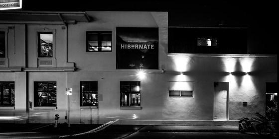
Monthly Social Night - February
642 Bridge Rd
19:30 – 21:30
Our regular monthly social night - this time at the Bridge Hotel in Richmond.
MEETING TIME | LOCATION: 7:30pm | The Bridge Hotel, 642 Bridge Rd, Richmond.
PUBLIC TRANSPORT: Tram #48 (via Collins St) or #75 (via Flinders St) to stop 22.
ACTIVITY DESCRIPTION:
Join us for our monthly social evening where members can enjoy a meal, talk about upcoming events, compare notes on past activities and float ideas on events they would like to see run.
LEADER | BOOKING: Garry O. | by Monday 4th February. Email the Leader if you have any questions. Members can access leader contact details under Members->Leader Contacts when logged in to the website.
Feb
03
2019
Past Event
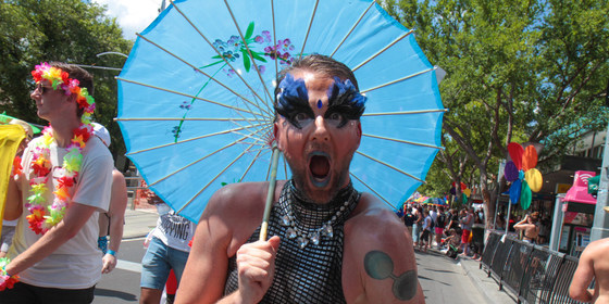
Midsumma Pride March
Ian Johnson Oval
10:30 – 16:00
Gather your friends together and head along to Fitzroy St, St Kilda to march with The Nomads in the annual Midsumma Pride March. The march begins at 11am, with assembly prior to that on the Ian Johnson Oval, cnr Lakeside Drive and Fitzroy St, St Kilda. See Midsumma Pride March for comprehensive details.
LEADER | BOOKING: Garry O. | by Saturday 2nd February. Email the Leader if you have any questions. Members can access leader contact details under Members->Leader Contacts when logged in to the website.
Jan
27
2019
Past Event
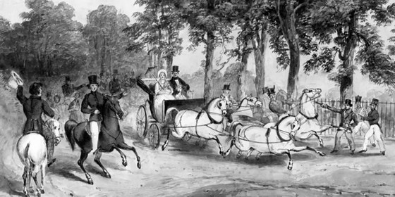
Midsumma Assassins Walk - Albert Park to Carlton
Albert Park Station/Light Rail
10:00 – 16:00
A walk through beautiful old Melbourne suburbs, with a twist. Learn about some of this city’s more colourful past.
GRADE | LENGTH | TYPE: Easy 12 km point-to-point walk using footpaths.
MEETING TIME | LOCATION: 10am at Albert Park Station/Light Rail, stop 128, cnr Bridport and Ferrars St, South Melbourne.
PUBLIC TRANSPORT: Tram 96 (East Brunswick to St Kilda via Bourke St) to stop 128.
MAP REFERENCE: Melway map 2K grid C6. Google map goo.gl/maps/CQeY6CwxkRR2.
TIME FROM GPO: Allow 20 minutes by tram.
FOOD: Pack food for lunch as we will have lunch in the Flagstaff Gardens. Food outlets are available en route.
APPAREL | FOOTWEAR: Comfortable footwear suitable for walking mostly on sealed footpaths.
ACTIVITY DESCRIPTION:
This walk will follow the Melbourne locations in the double life of John Freeman, who was born Edward Oxford and who at the age of 18, attempted to assassinate a young 21 year-old Queen Victoria on 10th May 1840 as she rode out of Buckingham Palace with Prince Albert. Edward changed his name when he arrived in Melbourne in 1857 following 24 years in Bethlam Lunatic Asylum. He transformed his life and made a great contribution to colonial life in Melbourne. No-one ever knew of his double life background.
The walk will commence at his residence in Albert Park, then proceed through South Melbourne and Docklands onto St James Old Cathedral in West Melbourne, Melbourne's oldest church and a beautiful example of Georgian architecture. Edward/John became church warden there and ironically, the church holds a personal gift to the Colony of Victoria from Queen Victoria. We will lunch in the nearby Flagstaff Gardens then proceed through leafy Victorian Carlton to the Melbourne General Cemetery where Edward /John is buried.
The walk will include some background on Edward's early life, the assassination attempt and his subsequent trial for treason, the legal repercussions on the nature of policing throughout the then British Empire as a result of his actions that May day in 1840, and his transformed life during the decades of 19th century Marvellous Melbourne.
The walk will end in Carlton at the cemetery at approximately 4pm followed by an arvo tea in Lygon St, Carlton. Frequent trams run down nearby Swanston St back to the City.
LEADER | BOOKING: Don V. | by Thursday 24th January. Email the Leader if you have any questions. Members can access leader contact details under Members->Leader Contacts when logged in to the website.
Jan
26
2019
Past Event
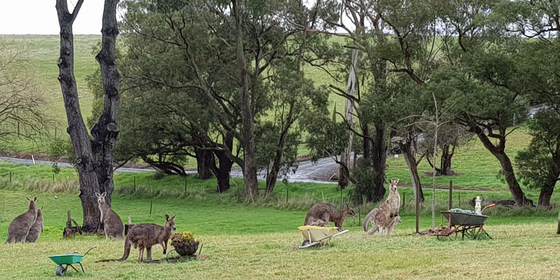
Australia Day – Picnic in the Yarra Valley
Macclesfield
12:00 – 17:00
Enjoy a casual picnic on Australia Day on the property of a Macclesfield member, which includes a swimming pool, expansive outdoor picnic area, historic features and some delightful walking trails.
GRADE | LENGTH | TYPE: Social - Australia Day picnic with optional camp out overnight at "Blanchfields", a private home overlooking the Yarra Valley.
MEETING TIME | LOCATION: From midday onwards at the private home of member Robert A. located in Macclesfield (past Emerald). Address will be forwarded once you have booked a ticket .
MAP REFERENCE: Melway map X912 grid R4 | Google map goo.gl/maps/KBZiiJpW2uj.
DISTANCE | TIME FROM GPO: 1 hour – about 60 km.
TRANSPORT: No public transport. Travel by car and carpool with someone else if you can. Take the Monash or Eastlink Freeway and exit at Wellington Rd then continue to Macclesfield. The full address and travelling directions will be provided to you upon receipt of your RSVP.
FOOD: Bring your own food and drink. For those staying the night, there will be shared drinks, nibbles and meal on the deck at sunset. Until we know how many will be taking part, let’s just call it a “potluck dinner”, any contributions gratefully received.
APPAREL | FOOTWEAR: Bring your own hat, sunscreen and insect repellent. Dress according to the weather forecast.
ACTIVITY DESCRIPTION:
We are very privileged to be invited to an Australia Day picnic in the private and beautiful gardens of the home of member Robert A. You will remember Blanchfields if you enjoyed the Australia Day Picnic in previous years. It is a rural property with a large garden of exotic trees and shrubs, grasslands and some bushlands overlooking the Yarra Valley. Robert has also invited those who wish, to stay the night after the day of revelry. You are welcome to set up your tents or trailers in the gardens and leave the next day. In that case, Robert will direct you where you can set up camp.
The event starts from midday onwards. There are a limited number of chairs and tables as well as a toilet and bathroom for use. Note – this is not a barbeque. Fires are not allowed in a high fire danger area. Enjoy the swimming pool and stay over in your tent or camper if you wish. There will be access to the oven/stove if anything needs cooking or heating up. Plus, the vegetable garden should be in full production if we need additional ingredients. Updates will follow closer to the date.
LEADER | BOOKING: Robert A. | by Wednesday 23rd January. Email the Leader if you have any questions. Address will be forwarded once you have booked . Members can access leader contact details under Members->Leader Contacts when logged in to the website.
Jan
13
2019
Past Event
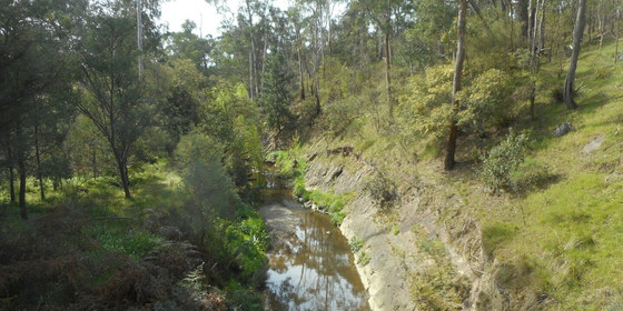
Mullum Mullum Creek Walk - postponed to Sunday 2nd June
Flinders Street Railway Station
10:32 – 16:00
Enjoy a casual walk along creekside bushland reserves including a recently opened section of the Mullum Mullum Creek trail. This event has been postponed until Sunday 2nd June due to public transport issues.
GRADE | LENGTH | TYPE: Easy, approximately 11 km, point-to-point walk on sealed and unsealed walking and cycling tracks.
MEETING TIME | LOCATION: Meet in the front carriage of the Belgrave train departing Flinders Street Railway Station at 10:32am or join the group en route by arrangement with the event leader.
MAP REFERENCE: Melway map 43 grid H9 | Google map goo.gl/maps/NMdRVJfVevp.
TRANSPORT: Access to this walk is by public transport only. We travel by Metro train with a 50 minute journey to Heatherdale on the Belgrave train departing Flinders Street Railway Station at 10:32am. The return journey to the city takes 40 minutes on the 906 bus from Deep Creek Reserve, Doncaster East. All travel is within myki zones 1 & 2 with weekend daily caps of $6.30 full fare, $3.15 concession and free for seniors.
FOOD: Carry lunch, snacks and at least 1 litre of water.
APPAREL | FOOTWEAR: Comfortable walking boots/shoes and dress according to the weather forecast.
ACTIVITY DESCRIPTION: Our walk commences at Heatherdale Railway Station with a short stroll along the street to the Mullum Mullum Creek Reserve. We pass by Schwerkolt Cottage & Museum Complex to reach Yarran Dheran Nature Reserve where we will enjoy lunch in one of the bushland picnic areas. Proceeding along Mullum Mullum Creek we walk through a section of creekside bushland saved from the Eastlink Tollway by the contruction of 1.5 km tunnels. We follow the Mullum Mullum Creek Trail for the remainder of the walk including a recently completed section with several new bridges. Our walk concludes when we reach Heidelberg-Warrandyte Road at Deep Creek Reserve where the 906 bus departs every 30 minutes for the 40 minute journey back to the city.
FURTHER INFORMATION: www.manningham.vic.gov.au/mullum-mullum-trail
LEADER | BOOKING: Peter Tocknell | ** This event has been postponed to Sunday 2nd June **. Email the Leader if you have any questions. Members can access leader contact details under Members->Leader Contacts when logged in to the website.
Jan
12
2019
Past Event
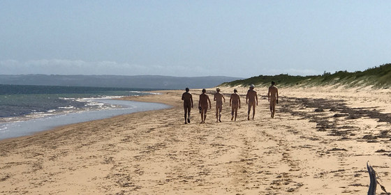
Nude Beach Day for Guys at Somers + afternoon tea nearby
121 Miramar Rd
10:45 – 16:00
Enjoy a day out at the Somers nude beach with an optional afternoon tea at a naturist's house nearby.
GRADE | LENGTH | TYPE: Easy 8 km circuit walk. It is 4 km one way, from the car park in Somers, along the beach towards Sandy Point, to a good set up place. The sand is fairly firm. Walking time is generally about 55 minutes to the set up place. Of course it is another 4 km back to the cars at the end of the day.
MEETING TIME | LOCATION: 10:45am in the car park at 121 Miramar Rd, Somers for socialising and briefing. We plan to depart for the beach at 11am. (There is no cafe near the meeting place sorry, you will need to bring your coffee with you). If you should miss us, walk to the back of the car park and go down the steep steps to the beach. At the bottom of the stairs turn left and walk for about 55 minutes and you should find our camp.
Address of the Afternoon Tea House: This will be emailed to all those who have booked by 10pm on Thursday 10th January. It will also be given out on the beach day.
TIDE FORECAST: High 5:25am - Low 11:15am - High 5:23pm. (Fortunately the high tide in the afternoon is not a very large high tide, so we should be able to get off the beach without too much trouble).
MAP REFERENCE: Melway map 194 grid F11 | Google map goo.gl/maps/34GNNdHTnyJ2.
DISTANCE | TIME FROM GPO: 86 km, 1 hour 40 minutes.
COST: The Nomads Outdoors Group has kindly offered to run their Beach Days for free for Visitors and Members. However we would still like you to obtain a ticket from their website, which means you will be an official member of the Beach Event and will be covered by their insurance.
FOOD and BEVERAGES: Carry lunch, snacks, water and food/drinks for the beach day.
Afternoon Tea: Please bring some food to share for optional afternoon tea at a fellow nudist's house after the beach day. Tea and coffee will be provided. Bring cold drinks if you would prefer those.
Food Drop off in the Morning: If you'd like to drop off food before you come to the beach, you may drop it at the house in Bittern between 10am and 10:30am. The house is 1 hour 25 minutes, and 82 km from Melbourne - a long way! Make sure you plan your time. From the house to the meeting place it is an 8 minute drive.
APPAREL: Sunscreen, hat, sunnies, footwear if the sand is hot. Shorts required to get from car park to the beach.
EQUIPMENT: Towel. A picnic blanket with plastic backing or a large plastic sheet is handy, because in some places the grass seeds stick very tightly to your towel. You may wish to bring a sun shelter. The tee tree provides quite good, but not complete shade cover. Sporting equipment such as a frisbee, tennis ball, larger ball, small cricket bat etc. could be fun.
ACTIVITY DESCRIPTION:
This event is for naturists. Enjoy a pleasant beach day and walk with fellow nude guys, followed by nude afternoon tea at a fellow nudist's residence in Bittern, 8 minutes drive away. Afternoon tea and snacks will probably start between 4pm and 5pm, but the time could vary depending on the weather.
LEADER | BOOKING: Peter H. | by Friday 11th January. You can contact Peter on 0402 485 610 or peteinmel@hotmail.com if you have any questions.
Jan
08
2019
Past Event
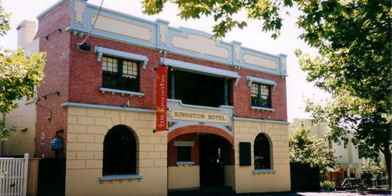
Autumn Planning & Social Night
Kingston Hotel
19:00 – 21:30
Our quarterly planning night, in conjunction with the regular monthly social night.
MEETING TIME | LOCATION: 7pm | Kingston Hotel, 55 Highett St, Richmond for planning followed at around 7:30pm by the monthly social event.
MAP REFERENCE: Melway map 2G grid H4 | Google map goo.gl/maps/FmV6iTSDJis.
PUBLIC TRANSPORT AND PARKING:
Train: Mernda / Hurstbridge to West Richmond Station.
Tram: #48 or #75 to stop 14.
Car: There is limited parking available in Highett Street.
ACTIVITY DESCRIPTION:
Do you want to see more of a particular activity, or do you have a particularly favourite area of Victoria you would like to share with others? Do you have an idea for something apart from the regular walks? Come along to the planning meeting, and then stay for our monthly social evening where members talk about upcoming events, share a meal and compare notes on past activities. All members are welcome – you don't have to volunteer for an activity. New members are especially invited to this meeting as an orientation to Nomads activities.
LEADER | BOOKING: Alan D. | by Monday 7th January. Email the Leader if you have any questions. Members can access leader contact details under Members->Leader Contacts when logged in to the website.
Jan
06
2019
Past Event
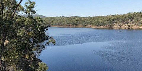
Mixed Nude Walk & Swim - Djerriwarrh Reservoir, Toolern Vale
1486 Diggers Rest-Coimadai Rd
10:15 – 16:00
A naturist walk in a scenic, remote location not too far from Melbourne.
GRADE | LENGTH | TYPE: Medium, approximately 9 km circuit walk. About 3 hours walking time plus 1 hour lunch and swim stop. We walk on 4WD tracks, single lane walking trails and kangaroo pads. About 3 km is on kangaroo pads and the walking speed is quite slow. There are some moderate hills but they are not that long.
MEETING TIME | LOCATION: Meet at 10:15am at the Toolern Vale General Store for coffee and registration. The exact address is 1486 Diggers Rest-Coimadai Rd. We plan to drive to the start of the walk at about 10:45am. There is a good car park opposite the General Store.
MAP REFERENCE: Melway map 331 grid G5 | Melway Key Map 7 grid E3 | VicRoads Map 78 grid B3. | Google map goo.gl/maps/nZfzrbFUSJr.
WALK LOCATION: Entry is via a private farm property north west of Toolern Vale.
DISTANCE | TIME FROM GPO: 50 km, 45 minutes. Travel via the Calder or Western Highways.
FOOD and BEVERAGES: Lunch, snacks, water/drink to take on the walk.
APPAREL: Comfortable shoes/boots. Shorts or similar to wear at the start and finish of the walk, while on private property. Sunscreen, sunhat, sunglasses. Towel to dry off after swimming. If the day is a bit cool or you need protection from the sun, clothes can be worn to keep you comfortable. Lightweight sandals or thongs would make it easier to walk on the small stones at the edge of the reservoir when you go in for a swim.
ACTIVITY DESCRIPTION:
This event is for Naturists. A lovely remote spot, not far from Melbourne where we can shed our clothes and enjoy naturist walking and swimming. The reservoir is quite a large body of water and there is plenty of water there all year round. The reservoir is hidden in the Pyrete Forest and is most picturesque.
We have visited this reservoir two or three times before and are hoping to find a different way in to it this time.
Afternoon Snacks and Drinks: After the walk we will return to the Toolern Vale General Store to collect the cars that we didn't take to the start of the walk. If desired, we can have a cool off drink or coffee there, or if some would prefer we could drive to Melton for a beer or coffee at Mac's Hotel, 322 to 332 High St, Melton (11 km and 10 minutes drive from Toolern Vale).
LEADER | BOOKING: Russell W. | by Thursday 3rd January. Email the Leader if you have any questions. Members can access leader contact details under Members->Leader Contacts when logged in to the website.
Jan
01
2019
Past Event
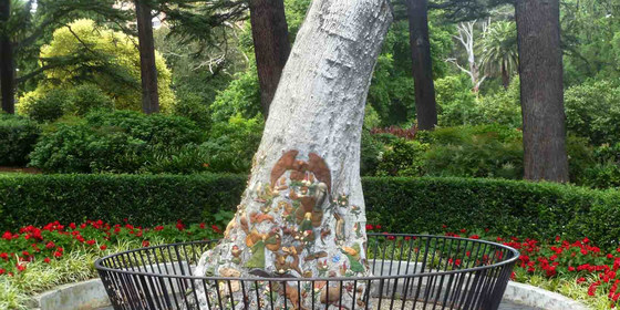
New Years Day Picnic - Fitzroy Gardens "CANCELLED"
The Fairies Tree
12:00 – 16:00
PICNIC CANCELLED DUE TO INSUFFICIENT INTEREST
Start the new year with a relaxed picnic in the Fitzroy Gardens followed by a stroll around the expansive park.
GRADE | TYPE: Easy, social.
MEETING TIME | LOCATION: 12 noon at the Fairies Tree opposite the miniature Tudor Village and old Pavillion Cafe, Fitzroy Gardens, East Melbourne.
MAP REFERENCE: Melway map 44 grid B8 | Google map goo.gl/maps/ttBUYt2Y1sx.
DISTANCE | TIME FROM GPO: Approximately 2 km, 15 minutes by public transport.
PUBLIC TRANSPORT: Fitzroy Gardens are easily accessible by trams 48 and 75 along Wellington Pde and Mernda/Hurstbridge line trains to nearby Jolimont station.
FOOD and BEVERAGES: All available in the nearby CBD.
APPAREL: Dress appropriately for forecast weather conditions and wear comfortable footwear for walking around the gardens.
ACTIVITY DESCRIPTION:
Happy New Year! Let us celebrate the arrival of the new year and new resolutions by getting together in the delightful Fitzroy Gardens for a BYO everything picnic. Remember to also bring something comfy to sit on and protection from the harsh Summer sun.
LEADER | BOOKING: Peter N-G. | by Monday 31st December. Email the Leader if you have any questions. Members can access leader contact details under Members->Leader Contacts when logged in to the website.
Dec
29
2018
Past Event
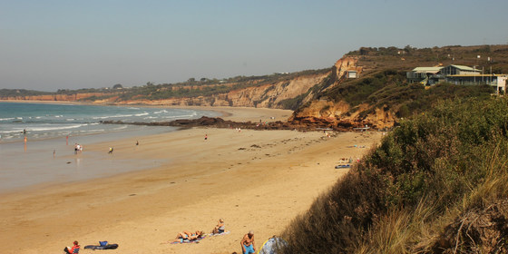
Anglesea Beach Day Trip for Lunch, Walk & Optional Swim "CANCELLED"
Southern Cross Station
10:15 – 16:00
"EVENT CANCELLED DUE TO ADVERSE WEATHER CONDITIONS & LACK OF INTEREST"
Head to a local Surf Coast beach for a walk and swim during the Christmas/New Year holiday week.
GRADE | TYPE: Easy, social.
MEETING TIME | LOCATION: 10:15am at Melbourne Southern Cross Station inside the front carriage of the 10:30am Waurn Ponds (Geelong) service.
MAP REFERENCE: Melway map 43 grid E9 | Google map goo.gl/maps/NSbSRwfkLb22.
DISTANCE | TIME FROM GPO: Approximately 114 km, 2 hours by train/coach.
FOOD and BEVERAGES: All available at Southern Cross or in Anglesea. Remember to bring at least 1 litre of water.
APPAREL: Dress appropriately for the forecast weather conditions and as it is a day beside the seaside and we do like to be beside the sea please bring everything you need for that sort of day including something comfy to sit on and especially protection from the harsh Summer sun.
ACTIVITY DESCRIPTION:
Enjoy a day during the festive season on a Surf Coast beach including a picnic lunch, maybe a swim and a walk along the beach and around this pretty town.
Note: this Anglesea Beach visit may be rescheduled to the next day, Sunday 30th December, if the weather forecast is not favourable for the Saturday.
LEADER | BOOKING: Peter N-G. | by Friday 28th December. Email the Leader if you have any questions. Members can access leader contact details under Members->Leader Contacts when logged in to the website.
Dec
26
2018
Past Event
Boxing Day/Orphans Xmas Picnic, Stroll - St Kilda Botanical Gardens "Sunny 26 Degrees"
St Kilda Botanical Gardens
12:00 – 16:00
Enjoy a leisurely post-Xmas picnic lunch followed by a stroll around the St Kilda Botanical Gardens.
GRADE | TYPE: Easy, social with a short walk.
MEETING TIME | LOCATION: 12 noon inside the Herbert St entrance outside the toilets. At approximately 12:15pm we will move to a shady location near the Canary Island Date Palm. If you are a late arrival, you will need to search for us or try to contact the leader by phone.
MAP REFERENCE: Melway map 58 grid B12 | Google map goo.gl/maps/iXQqoq9eNtM2.
PUBLIC TRANSPORT:
Tram: 96 to the Acland St terminus then cross Barkly St | there are various other tram services in nearby Chapel St, Carlisle St and Brighton Rd.
Bus: 246 bus along Barkly St alighting at Acland St | 600/606 buses along Mitford St.
DISTANCE | TIME FROM GPO: Approximately 8 km and 40 minutes by public transport.
FOOD and BEVERAGES: All available on nearby Barkly and Acland Sts. Always remember to carry at least one litre of water.
APPAREL: Dress appropriately for the forecast weather conditions, with comfortable footwear for walking around the gardens.
ACTIVITY DESCRIPTION:
For those who find themselves alone on the Christmas/Boxing Day public holidays we are having an Orphans Xmas on Boxing Day, so whether you feel like some company or just feel like a picnic in the delightful St Kilda Botanical Gardens then join us. Remember it is BYO everything including something comfy to sit on and protection from the harsh rays of the Summer sun. After lunch we can have a leisurely stroll through the gardens.
LEADER | BOOKING: Peter N-G. | by Monday 24th December. Email the Leader if you have any questions. Members can access leader contact details under Members->Leader Contacts when logged in to the website.
Dec
16
2018
Past Event
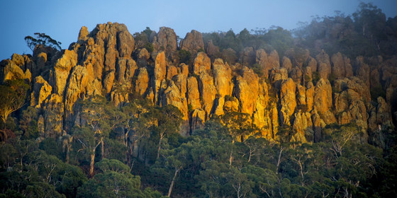
Woodend to Hanging Rock Circuit Walk & Picnic with Miranda
Southern Cross Station
08:45 – 16:00
Enjoy a Sunday walk in the historic goldfields region, with a picnic and exploration of the mystical, intriguing and beautiful Hanging Rock.
GRADE | LENGTH | TYPE: Moderate, 16 km circuit walk.
MEETING TIME | LOCATION: 8:45am at Melbourne Southern Cross Station in front carriage of the 9:02am Bendigo service.
MAP REFERENCE: Melway map 1A grid A6 | Google map goo.gl/maps/rGAqyBs7jmp.
DISTANCE | TIME FROM GPO: Woodend is approximately 71 km from Melbourne and approximately 1 hour by train.
FOOD and BEVERAGES: All available at Southern Cross Station or Woodend for the journey – BYO picnic for lunch at Hanging Rock. Remember to bring at least 1 litre of water.
APPAREL: Dress appropriately for the forecast weather conditions with comfortable footwear for walking beside public roads and around Hanging Rock.
ACTIVITY DESCRIPTION: Enjoy a train ride, a walk alongside country roads and that infamous "Picnic at Hanging Rock" with maybe even Miranda, Marion or Miss McCraw in attendance in spirit. "Picnic at Hanging Rock" was a novel written by Joan Lindsay and subsequently turned into a motion picture masterpiece by director Peter Weir, about a group of schoolgirls and their teachers who travel to the rock at the turn of the 20th century for a Picnic with three of them disappearing without a trace. It was always believed to be based on a true story, but before her death Lindsay was said to have revealed that it was historical fiction. It is all for you to decide.
Our day will commence at Melbourne Southern Cross Station where we will board the 9:02am Bendigo service for our journey to Woodend from where we will walk alongside country roads for approximately 8 km until we reach the picnic area at Hanging Rock ($4 entry fee) where we can gaze upon this geological marvel before setting down in a shady location to enjoy our BYO-everything lunch. After lunch we may climb the rock to explore its many natural features – do not get lost now – and maybe even walk around the base.
Our return to Woodend will be at our leisure via the same route to enjoy some afternoon tea before boarding a return train service to Melbourne which operate hourly.
LEADER | BOOKING: Peter N-G. | by Thursday 13th December. Email the Leader if you have any questions. Members can access leader contact details under Members->Leader Contacts when logged in to the website.